I remember a video that amazed me in my youth — in the years when there were no personal computers, no good graphics, no multi-colored moving pictures. Essentially, the video was a rather crude cartoon, monochrome, with huge pixels, about the movement of continents.
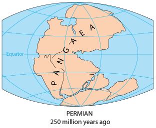
The video began with a time when Pangaea existed — all the land was gathered into one continent. This was 200 million years ago (not the most ancient period in Earth’s history, but one of the most striking episodes known to us). Dinosaurs still lived on Pangaea, inhabiting the vast ancient forests of this continent.
The splitting process went slowly. First came the division into Laurasia (the northern continent) and Gondwana (the southern continent). Between them formed the Tethys Ocean.
Laurasia included present-day North America, Europe, and part of Asia. Gondwana, on the other hand, united South America, Africa, India, Australia, and Antarctica.
Source: Wikimedia Commons https://commons.wikimedia.org/wiki/File:Pangaea_Breakup.gif Author: Carie Frantz (Carie027)
Gondwana was the first to begin splitting. South America broke off from Africa. Even on the modern map, we can fit them together. Between them began forming what is now the second-largest ocean — the Atlantic.
India broke off from Africa and began moving northeast, deeply penetrating into Asia. The enormous folds that grew in this place instead of the Tethys Ocean are Tibet and the Himalayas, the highest mountains on the planet.
Antarctica and Australia, still connected together, broke off approximately in those same millions of years.
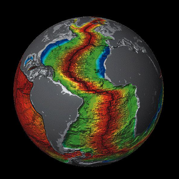
Then came the turn of Laurasia, which divided into North America and Eurasia. The largest crustal rift that separated both Americas runs along the bottom of the Atlantic Ocean, and volcanoes continue to be active underwater… Part of this ridge, crossing the ocean from north to south, emerges on land in Iceland, in the form of active volcanoes Eyjafjallajökull, Grímsvötn, and others.
Source: Wikimedia Commons https://commons.wikimedia.org/wiki/File:Atlantic_Oceanic-Crust.jpg Author: USGS.
The continents continue to move at a speed of approximately 2 to 10 centimeters per year (someone noted that this is roughly the same speed at which human fingernails grow).
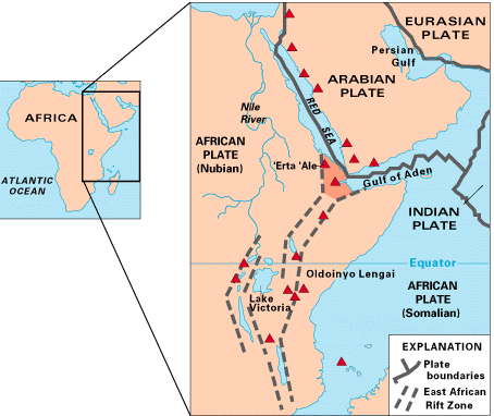
The Earth is constantly changing. Now (in the last few million years) a new rift is forming, which soon (by geological standards) will separate the eastern part of Africa.
Source: Wikimedia Commons https://commons.wikimedia.org/wiki/File:Tectonical_map_of_East_Africa.png Author: USGS